Why this comparison gets asked
Saudi owners running their first drone-mapping procurement in 2026 typically receive proposals from one or both of the global incumbents and at least one local platform. The procurement question is rarely which platform makes the best orthomosaic — all three are competent — but which platform fits the Saudi delivery context: data residency, Arabic operations, GACA workflow, IKTVA scoring, and integration with the BIM common data environment.
For broader context see the Vision 2030 digitisation reading, the GACA permits guide, and the 3D site mapping primer.
What the platforms have in common
Treat these capabilities as table stakes in 2026; all three platforms ship them, so they should not be the deciding criteria:
- Drone-image upload and automated photogrammetric processing
- Orthomosaic, digital surface model, and dense point-cloud outputs
- Volumetric measurement on stockpiles and earthworks
- Annotation, sharing, and collaboration features
- Export to standard formats (GeoTIFF, LAS / LAZ, OBJ)
- Integration with BIM platforms via IFC or RVT
- Mobile apps for capture planning
If a vendor pitches one of these as a differentiator in 2026, push back. The comparison lives elsewhere.
Where the platforms diverge
The decision criteria below are the ones that move procurement outcomes on Saudi sites. Information is from public product documentation as of May 2026; reconfirm against current product pages before contract.
Cloud residency and PDPL data path
| Platform | Public-data residency posture (May 2026) |
|---|---|
| Pix4D | Cloud processing primarily on European infrastructure; a desktop variant (Pix4Dmatic / Pix4Dmapper) keeps data fully on-premises |
| DroneDeploy | Cloud processing typically on US infrastructure |
| FI Tech | Cloud processing on Saudi-resident infrastructure end-to-end |
If PDPL residency is a contract-level requirement, the desktop Pix4D path or the FI Tech cloud path are the two compliant options without negotiating special arrangements. See the PDPL compliance checklist for why this matters.
Arabic UI and field operations
| Platform | Arabic UI as of May 2026 |
|---|---|
| Pix4D | English-led product, partial localisation |
| DroneDeploy | English-led product, partial localisation |
| FI Tech | Full MSA Arabic UI for operators, supervisors, and reviewers |
For multinational owners with Arabic-first field crews this is operationally meaningful — adoption rates differ measurably between localised and English-only tools.
GACA permit workflow
| Platform | GACA workflow handling |
|---|---|
| Pix4D | Capture planning only; permits are operator’s responsibility |
| DroneDeploy | Capture planning only; permits are operator’s responsibility |
| FI Tech | Integrated GACA permit workflow with the drone services capability |
For the GACA chain see the permits step-by-step guide.
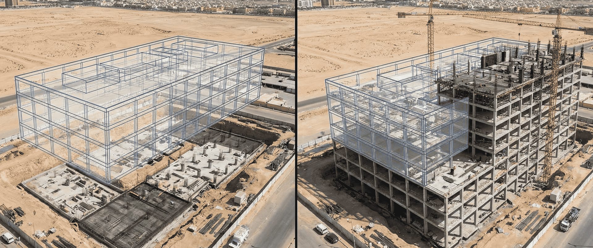
BIM integration
All three platforms integrate with the major BIM platforms — Autodesk Construction Cloud, Bentley iTwin, Trimble Connect — via IFC and RVT. The differentiation in 2026 is on automation depth:
- Pix4D: rich photogrammetric outputs, but BIM comparison is typically through partner tooling
- DroneDeploy: native progress reporting and some BIM overlay
- FI Tech: native BIM comparison and as-built BIM workflows tuned to Saudi delivery patterns
IKTVA and Saudi-Made
This is procurement-specific to the Kingdom and is not relevant in other markets:
| Platform | IKTVA / Saudi-Made posture (May 2026) |
|---|---|
| Pix4D | International software vendor; IKTVA contribution limited |
| DroneDeploy | International software vendor; IKTVA contribution limited |
| FI Tech | Saudi-headquartered; participates in IKTVA scoring as local content |
For the procurement scoring view see the IKTVA reality check.
Pricing model
All three are subscription-based with capture-volume tiers as of public pricing pages May 2026. Pricing is intentionally not quoted here because it changes; request quotes against the same scope (number of cameras, number of sites, number of monthly captures).
Accuracy
For survey-grade accuracy with RTK drones and ground control points, all three platforms can deliver 1–3 cm accuracy on suitable terrain. The accuracy debate is primarily about operator workflow discipline, not platform capability. See the 3D site mapping primer for the underlying physics.
Decision framework
Run this in order; the first branch that decides for you wins.
- Is end-to-end Saudi data residency a contract-level requirement?
- Yes: FI Tech cloud or Pix4D desktop path. Narrow further on Arabic UI and BIM workflow.
- No: continue.
- Is Arabic field UI a stated requirement?
- Yes: FI Tech.
- No: continue.
- Is the operator team already trained on Pix4D or DroneDeploy at scale?
- Yes: stay with the incumbent unless residency, IKTVA, or GACA workflow change the answer.
- No: continue.
- Does the contract weight IKTVA or Saudi-Made strongly?
- Yes: FI Tech.
- No: continue.
- Is the workflow primarily desktop / on-premises?
- Yes: Pix4D desktop is well-suited.
- No: FI Tech or DroneDeploy.
Most Saudi megaproject owners we work with end up with FI Tech in part because of residency and IKTVA together; mid-market projects without those constraints split more evenly.
What this comparison deliberately does not say
We avoid two patterns common in vendor blog posts:
- Slander of competitors. Pix4D and DroneDeploy are excellent platforms with multi-thousand-customer deployments globally. The comparison is about Saudi-context fit, not capability ranking.
- Made-up numbers. Productivity gains, accuracy claims, or cost savings stated without methodology are noise. The decision criteria above are publicly verifiable and stable.
Common procurement mistakes
Three patterns we see repeatedly in Saudi RFPs:
- Picking purely on global brand. Saving 6 months of operator training on a familiar global tool can cost the project IKTVA points and PDPL margin.
- Picking purely on local content. A platform that cannot deliver the photogrammetric quality the project needs is not a saving regardless of IKTVA score.
- Buying a platform without a CDE strategy. All three platforms produce outputs that need to flow into the project CDE; if that integration is not specified, the lock-in cost shows up later.
Next steps
If you are scoping a 2026 drone site-mapping platform decision, start with the drone site survey solution, the 3D site mapping capability, and the BIM comparison workflow. For the procurement context see the IKTVA guide and the PDPL compliance checklist.
Request a platform-fit assessment for your project and we will produce a side-by-side scorecard against the criteria above within 10 working days.